
The 26 Hewitts of the Northern Pennines are dominated by mighty Cross Fell, a landmass just shy of 3000ft that dominates the view from the M6 and the West Coast Main Line south of Penrith. Crossed by the Pennine Way, it is, with its neighbours, by far the most frequently climbed of the group.
But it is fair to say that many hills of the northern Pennines have a poor reputation amongst hill walkers.
I’ve not, for the most part, found that well deserved. A bit damp in places, sure; some nasty peaty haggy stuff, though on my routes at least nothing too taxing; and in recompense, great wide open views, a total absence of crowds, and a chance to use your own ingenuity in route-building and -finding.

Great Stony Hill, with the Cross Fell ridge beyond
Four of northern England’s greatest rivers, the Eden, Tees, Tyne and Wear, help structure the group.
Cross Fell and its three neighbours, over to the south-west, are essentially Tees / Eden watershed hills. Like many others, I climbed them on a Pennine Way day.
Five hills lie south of the Tees – three of these are on the Warcop ranges, a live firing area that needs special permission to enter. There are nine hills between Tees and Wear, and three north of the Wear.
One of my first wild country expeditions, in 1974, saw me pick up five hills across these three groups; my 2015 cross-England walk deliberately sought out four more; another five followed in August 2023, and the Warcop hills in May 2024.
Last but by no means least, five Hewitts lie north of Cross Fell, between the Tyne and Eden. They were the focus of a successful visit in summer 2025, with a wild camp thrown in.
Cross Fell and its neighbours
I’m being quite restrictive in the definition here, by including only the four hills traversed by the Pennine Way on the memorable day from Dufton to Garrigill: Knock Fell (2605ft), Great Dun Fell (2782ft), Little Dun Fell (2762ft) and Cross Fell (2930ft).
(Topographically, Melmerby Fell and arguably Meldon Hill should be included too; but I’ve included them elsewhere.)
For me, the ‘memorable day’ was Tuesday 17 August 1976. I’d been on the top of Great Dun Fell (it’s the one with the weather station) five years previously, and rewalked the range in 1994. Details are on my High Pennines Pennine Way page, but here’s something else I found out, checking the back pages of my Wainwright guide.
I set off from Dufton at half past nine on a warm but breezy morning. Two hours later, I was on the top of Knock Fell, where I took a break. By 1 o’clock, I was on the top of Cross Fell. Time for lunch.
I was in Garrigill before 4. Again I hung around, but pressed on to Alston. I dawdled this a bit, getting there just after 6.
In all, just over 8½ hours; with breaks, just under 7½, for a little shy of 21 miles.
It’s only now, in my mid 70s, that I’d think I’d be a tad slower.

The Cross Fell range, from Round Hill
South of the Tees
Monday 27 May 1974: Meldon Hill from Langdon Beck, 14 miles
The second day of my northern Pennines half-term holiday; it will crop up elsewhere below. I took the Pennine Way out from the hostel, went straight up the hill, and came back by the eastern edge of the still fairly new Cow Green reservoir – I still have the OS map that I used, in which I’d shaded its rough outline!
The map, like all the other ’74 maps that follow, is a ’23 reconstruction from my ancient notes. These mention a few salient points along the way but the detail is bound to be approximate rather than exact.
Wednesday 30 August 2023: Bink Moss from Hargill Bridge, three miles
This was the third of three short walks of the day; Great Stony Hill and Chapelfell Top had featured earlier (see below).
I’d met grouse shooters the day before, so wasn’t too surprised to hear guns on the track running north from the bridge. Indeed, just at the point where I was to leave the track for the hill, there was a beater by an army-style truck, ready for a chat.
Yes, there were guns on the hill. But he was a helpful guy. Contour round the hill, then approach the top from the back. You’ll see more beaters up there, but you should be able to get to the wellies.
And it worked very nicely. I found a couple of cairns that seemed to mark a way up, and as I tracked towards the top, there were indeed more beaters, but they weren’t too interested and indeed seemed to have finished their business and started moving off as I approached.
The wellies? A couple of famous markers that have been on the heathery summit for many years. The 2031ft summit itself is a few yards north, not so nice.
I could clearly take a more direct line off the hill and indeed met the beater again back at the same spot. Dave, he was. “You can have a lift back to the road if you like,” he said. I reasoned with my conscience for, ooh, all of ten seconds, and hopped in. I found out that grouse shooting economics worked like this: £2000 a day paid by the guys (mostly) with guns; £80 a day for the beaters.

The cairn that led me to the plateau

The wellies of Bink Moss
Friday 3 May to Sunday 5 May 2024: the Warcop fells
This large area south of Knock Fell has been used for troop training, including live firing exercises, ever since WWII.
Much of the ground is therefore excluded from open access, meaning that careful pre-planning is needed to walk here legally. And that’s what I did.
The range is divided into three areas, and it happens that there’s one Hewitt in each.
Murton Fell (2215ft) presents the fewest problems; there is troop training but no live firing, and it is accessible at all times.
Against that, Little Fell (2454ft) is very much in the middle of the live firing zone, and the the MoD have a blanket ban on access to or near the summit – apart from one access walk per year conducted by the good people at North Pennines National Landscape (formerly AONB). The principal peak of the three, Mickle Fell (2585ft) is somewhat in-between, access-wise: it’s OK to walk on non-firing days, as long as you have been granted a permit.
I knew about the Little Fell access walk, and had emailed the AONB about it in 2023, but heard nothing. Early in 2024, they got back to me out of the blue with a date in May. This was just after I’d got myself a Mickle Fell permit for the same day! But the MoD let me shift the permit, so it all worked out very well.
Friday 3 May 2024: Murton Fell from Murton, five miles
This was very straightforward, just over two hours and that was with the added bonus of Murton Pike.
There’s a good easy track from the start which passes underneath the fell on its way towards High Cup. I left it at a tributary of Trundale Gill, on a bearing which led me over the highest ground – there is a cairn, but it’s by no means certain that it’s the highest point.
Here I met a party of three, couple Louise and Rich and son Joe. For mum and dad, this was their penultimate Hewitt, and Little Fell on Sunday would be their last! They’d come up by what is it seems the bagger’s path, which I’d wondered about just underneath some stone shelters, so I went back that way.
Though it’s not a Hewitt, Murton Pike is a much more enticing, indeed pyramidal, top and in good if somewhat hazy conditions it just begged to be climbed. There’s a steep direct descent, instead of going straight back to the track, and on such good firm grass it was almost a pleasure.

Louise, Rich and Joe wander over the high point of Murton Fell

Looking towards Cross Fell from Murton Pike
Saturday 4 May 2024: Mickle Fell from Cow Green, 12 miles
When you apply for a Mickle Fell pass, you have to specify which of two approved routes you wish to use: from the south or the north.
I plumped for the latter, even though it would be further from my accommodation near Appleby. That’s because I’d seen Mickle Fell many times from the Tees – Eden watershed walk that is such a highlight of the Pennine Way, and had often itched to ascend. Also, from the map the southern approach seemed to plough through a lot of boggy ground.
The northern route starts easily enough, soon joining the Pennine Way above Caldron Snout and following it to the old workings of Moss Shop. There’s a right-of-way from here to Maize Beck which I managed to miss on the way out by following a quad bike track, but once the beck is in view it was easy to handrail it to the crossing point. No spate today; a serious hazard, had it been. From here, it’s a simple, ie hardly steep at all, trudge up with fence on right and this time a quad bike track helping.
On the plateau – oh what a shame about the mist, I’d been looking forward to this – turn left on a path and you’re soon at a big cairn. Here I met Alison and Graham, who were bagging the county tops, just eight left. They’d come up from the south. The fell is now the county top of County Durham, but before the 70s it was the county top of all Yorkshire.
Same way back down but with a greater effort to actually follow the r-o-w from the beck to Moss Shop.

The smaller cairn is in fact the high point of Mickle Fell

The valley of Maize Beck
Sunday 5 May 2024: Little Fell from Hilton, ten miles
There were 12 of us gathered for the annual permissive walk to Little Fell, plus leader Jack of North Pennines National Landscape.
He’s a botanist so we had plenty of opportunity to find out more about the local flora; a side-bonus of being a military range is that there are few big mammals around to nibble or tramp on the interesting stuff.
Most of the group were close to finishing either the Hewitts, Nuttals or Simms, so we had a reason to be there, but this would be worth the walk even without this motivation. We approached by Scordale, the sheer western slope of Murton Fell above us, through old mine workings and up onto the plateau. One of us had an ultra-precise GPS device that led us to the cluster of stones at the true summit. Congratulations all round to Rich and Louise, who today completed their round of the Hewitts.

The western slope of Murton Fell

Rich and Louise complete their Hewitt round, with son Joe in the centre.
The trig point, a little south-east, is like no other: surrounded by a wind shelter, but in ruins – a direct hit from a shell? It’s certainly possible, as on the descent we were to see many pieces of old munitions. Don’t get too blasé about treading on stuff.
Two of our number were collecting the Nuttalls, an extended version of the Hewitts with a slightly lesser col height of 50 feet instead of 30 metres. They were keen to pick up the neighbouring Nuttalls of Tinside Rigg and Long Fell, and since they weren’t too far off track we did so. With the mist lifting a bit, it was a nice addition to the day on good ground. Finally, we dropped down to another r-o-w, into Swindale, soon rejoining our outward route.
Very much worth doing. We did come across a couple on the summit who were bunking the hill, but Jack’s expert knowledge and the company of others with the same obsession as me meant that ours was by far the better way of claiming the top.

Don’t touch!

Returning home
Between Tees and Wear
Viewing Hill (2129ft), Round Hill (2251ft) and Flinty Fell (2014ft) all featured on my 2015 cross-England walk.
I’ve trawled the archives, and found these two walks from the stay at Langdon Beck hostel which also included Meldon Hill (above).
Scroll beyond for the remaining hills, climbed in 2023.
Sunday 26 May 1974: Three Pikes and Westernhope Moor from Langdon Beck, 14 miles
‘Hot and sunny’, my notes said; I have a memory that the ground was firm underfoot all the way. Just as well.
A probably rather bemused YHA warden suggested I set off past the ski tow – it’s disappeared from maps since – on the way up to Three Pikes (2136ft). From here I skirted round Langdon Head, crossed a road at Harthope Head, and continued on to Fendrith Hill.
Westernhope Moor (2215ft) followed after Swinside Head. From here I’m less certain about my route; all I know is I finished at High Force, presumably the hotel. Quite possibly, I cadged a lift back along the road, rather than walk it.
Friday 31 May 1974: Ninebanks to Langdon Beck by the head of Weardale, 19 miles.
Between the Meldon Hill day (above) and this, I’d walked and hitched, or maybe taken the train, to Knock YH, Alston and on to Ninebanks YH.
Today was all about a return to Langdon Beck. I guess, I’d left my motorbike there.
Ninebanks hostel is high up in Allendale, a tributary of the Tyne. I went straight up into the hills at Hard Rigg and continued south-east, crossing very close to the summit of The Dodd (see below). I crossed onto the Tees / Wear hills at Killhope Cross, the summit of the A689.
This itself is over the 2000ft contour so the two-and-a-bit miles to Dead Stones (2329ft) doesn’t involve much climbing, neither does the mile-and-a-half to Burnhope Seat (2451ft). Whether it’s easy walking is another matter – the depression between the two hills looks decidedly messy.
From here I know I dropped down Harwood Common to the B6277 and returned to Langdon Beck. That would have been an anticlimactic four mile road walk at the end of a long day, but there’s no record of me hitching – not that the road sees many vehicles, even today. Perhaps I detoured down through Harwood proper. It will never be known.
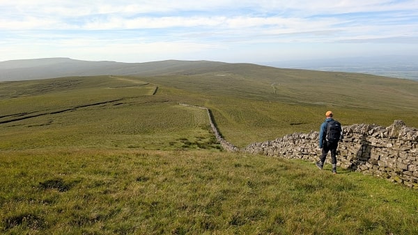
Wednesday 30 August 2023: Great Stony Hill (two miles) and Chapelfell Top (4½ miles)
Two separate walks.
First, I parked by the gate where a track from Burnhope meets the B6277.
Indeed, I’d been there 24 hours before, eyeing up possible showers, only to meet up with a guy setting up for that day’s grouse shoot just before I set off. I found I was likely to be in their way, and since lots of them had guns, and deferral by a day would be no loss to me, I scurried off to Allenheads (see below).
The next day happened to be even nicer. Great Stony Hill (2323ft) is easy from here, less than an hour’s round trip. I went out past the old mine workings of Blackway Hole until I could see a fence crossing the track, then veered up the hill. With cairn and trig point, and indeed a few stones, it’s one of the best viewpoints for the Cross Fell ridge, and indeed the northern Pennines in general.
From the summit I could see the top of the mine workings so I descended through them. I was back at the track in no time.

The old workings at Blackway Hole

The summit of Great Stony Hill
I then drove to Swinside Head for the climb of Chapelfell Top (2306ft). It can be done as an out-and-back but I never intended this – indeed I’d first planned to drive to Swinside Bridge and climb from there, until I realised it made no sense to drive to an iffy parking place when the Head had a very good one.
It did lead, unusually, to a downhill stretch at the start. Across on the Top, I could see what seemed to be mechanical diggers working. Surely not? Then I saw a team working beside a hut just off to my left. Wary by now of grouse shooters, I wandered over to find out what was going on. The diggers, they said, were some sort of peat restoration project.
They themselves were working at the Weardale Ski Club hut. The north-facing corrie below Fendrith Hill hosts some of the best snow conditions in England, and there are a couple of ski tows here and enthusiastic club volunteers to maintain them and the other facilities.
By now I could see that, rather then drop down to Swinside Bridge as planned, I might as well just continue on pretty much a direct line to Chapelfell Top. There was a bit of a drop down to Swinhope Burn but from there I set myself a compass bearing and began the trudge uphill. I was expecting boggy, peaty stuff but it was all pretty straightforward.
Until I got to the ‘ridge’. This was just a mess of peat hags, with the cairn thankfully close at hand. So were the diggers, but they were silent, with no sign of their presumably human operatives. Spooky.

The summit of Chapelfell Top …

… and the diggers
Running south from the summit, there’s a broad drain which gives the best route towards Fendrith Hill, though there’s still a bit of peat hopping. If it was wet this would be tough indeed. Things don’t really improve until you’re past the top of the ski tows, when a sturdy stone wall appears, indicative of firmer ground. Swinside Head is then not far away.

The gully running south from the Top

Top of the ski hoists
North of the Wear
I’d crossed the shoulder of The Dodd (2014ft) back in ’74, but not it seems the summit. However it did feature on my 2015 cross-England walk.
Tuesday 29 August 2023: Killhope Law and Middlehope Moor from Allenheads, nine miles.
This is quite a nice little round, with conditions on the long connecting ridge far better than I expected.
Allenheads itself is a fascinating little place, with a good café and plenty of explainers to the industrial history all around you. The village once processed all the lead from the mines on the surrounding hills.
After a short road section down to Dirt Pot, the ascent to Killhope Law (2208ft) is mostly by an old track leading to a decrepit shooting lodge. The stonework on the front looked as if it might collapse at any moment, so I didn’t venture in, but there were signs that some use it as an occasional howff.
The summit is only about 500 metres from here, with a bagger’s path. The cairn, not quite the high point, bears a helpful iron sign stating ‘Killhope Law’.
It was donning waterproofs in a short shower that three beaters came up the hill from the west. If I had planned to straight back to Allenheads, I would have been in their way, as they explained they were shooting on the slopes to the north of the ridge. I described my route, over Westend Moor, and there was no clash.
They did think though that it might be slow going. As it happened, there was a quad bike track more or less easy to follow all the way, and conditions to the Allenheads – Weardale road weren’t bad at all.

The cairn on Killhope Law

Westend Moor
Middlehope Moor (2008ft) doesn’t have anything like a good reputation, but the climb from the road is straightforward enough. Thankfully the summit is reached before the wettest ground, over to the east.
I’d planned to return to the road and walk down it back to Allenheads, but one of my sources recommended following the fence NNE through ‘wet moorland’ – indeed, from the map, it seemed to follow a drain. Not fancying either, there seemed to be a path by the wall roughly in between the fence and the road, and this proved to be a good way down, with great views along Allendale. Only one section, by a patch of forestry, was noticeably damp.
A cut-off path avoids a big zig-zag in a minor road, and Allenheads is then reached in no time.

The summit of Middlehope Moor

Looking over Allendale
Between Tyne and Eden
In summer 2025, I booked myself a few days in Alston to climb these five hills, with relocation to a wild camp at the end.
It’s possibly this group that has the most difficult reputation, though with one exception (and that could have been avoided) I found no real issues.
Thursday 26 June 2025: Grey Nag and the South Tynedale Railway, ten miles.
Plan A was to park at Castle Nook, bag Grey Nag (2152ft), continue to Tom Smith’s Stone, then return by Gilderdale Burn.
Only a half day, I thought, and since it was a wet morning I thought let’s take a trip on the South Tynedale Railway first.
Then I had another look at the map, saw that Kirkhaugh station was close to Castle Nook, and that the return would put me only a couple of Pennine Way miles from being back in Alston. So that was Plan B, as recorded here.
Sane people just go up from Castle Nook and come straight back down again.
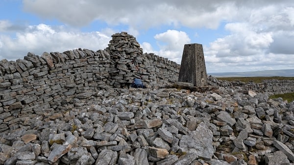
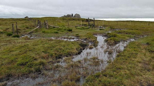
Not that it starts too badly, slanting up through pasture and keeping the bull and its cows under sharp observation. It would help if I’d slanted higher so that I could have used the gate at 683481ish rather than negotiate a barbed-wire wall. Otherwise though, it’s not too bad a climb to the notable summit with its cairn and 2152ft trig point, plus a currick just below.
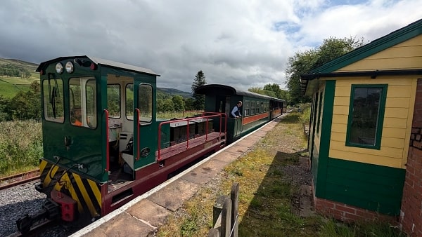
Kirkhaugh station
Grey Nag summit
I can’t even complain about the mile to Tom Smith’s Stone, no wetter than one would expect, or indeed the drop down to the valley bottom.
No, it’s the hour-and-a-half to negotiate the two-and-a-half valley miles that takes the shine off this day. There’s never any chance to get a stride on, as the terrain constantly changes – tussocks here, heather there, bracken over the rise, none with a hint of path. Plus, there’s another bit of barbed wire, inescapable this time.
It was a relief to reach the Pennine Way and something like a proper path, and there was the bonus of Alston in the evening light. But at five hours, it felt far longer.
Tom Smith’s Stone
Gilderdale Burn, and the Pennine Way at last
Friday 27 June 2025: Cold Fell from Clesketts, 6½ miles.
Much, much better that the day before, even though the weather was somewhat worse.
The Met Office were confident of a dry afternoon on this most northerly Hewitt (2037ft); at least, I suppose, it was only showers.
There are decent paths all the way, indeed a hard surface to the farmstead of Howgill. From here a rough track rises to the saddle beween Tindale Fell and Cold Fell, and then a path hugs a fence all the way to the top and then over.
It was raining quite hard by now, but frankly a good pace on a gently descending if rather splashy path was rather fun.
I’d got the idea for this circuit from the North Pennines National Landscape High Level Walk #2. This recommends leaving the fence on descent in the direction of the old colliery at Gairs, but it’s pathless, and it’s clear that most walkers nowadays just stick to the fence. This gets you to the old railway coming from Gairs soon enough.
I thought this might have been an easy shingled path, but nature has made a good go of recolonising it. However there are no real difficulties, and Howgill and soon Clesketts are reached in good time.
The summit of Cold Fell
Looking north from the Gairs railway, abandoned quarry mid-distance
Saturday 28 June 2025: Thack Moor from Lazonby, 10 miles. Sunday 29 June 2025: Black Fell and Melmerby Fell to Langwathby, 13 miles.
This year’s wild camp with Adrian weekend. Worth doing, though there are far easier ways of doing these three Hewitts.
I drove over from Alston, where I had been based for Grey Nag and Cold Fell, to Langwathby station and joined my son on the train up from his home in Shipley, leaving the next stop down the line at Lazonby. It’s an easy walk to the next village of Kirkoswald, where we had a break at the excellent Fetherston Arms. The three miles onward to Renwick are mostly beside the pretty Raven Beck – a lovely way to warm up.
Thack Moor (2000ft) is, like Calf Top in the Dales, one of those Hewitts-by-just-inches that have been added to the list only in recent times.
Like its partner, it’s by no means an unwelcome addition. There’s an easy, steady track up almost all the way from Renwick, and viewed from Hartside Cross the top looks almost pyramidal. But there’s one catch. The true summit lies the wrong side of the wall, which has a barbed wire top and no easy weakness. But nothing a 74-year-old can’t surmount, if a trifle ungainly.
Though yesterday’s rain had all but gone, the mist was down, and a strong sou’westerly blowing. By and large it was straightforward enough, there being either a quad bike track or a thin trod heading in the right direction, easy gradients, and wall stiles or similar in all the right places. The three miles towards Black Fell took us just over an hour.
I say ‘towards’ – the plan was for a summit camp, but there would have been no shelter, so we chose to pitch just below, where a wall protected us from the worst of the wind.
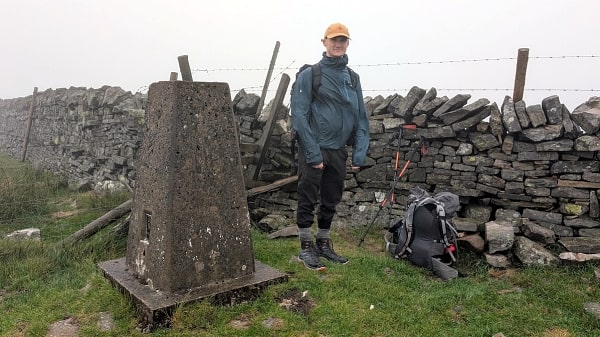
Adrian at the trig point on Thack Moor
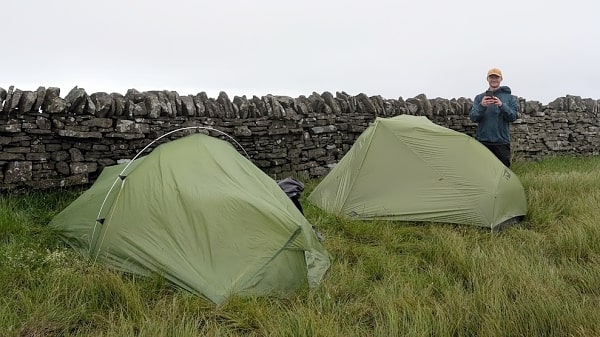
The wild camp
The next day we awoke to light winds and blue skies, and indeed this was to prove a beautiful day for walking.
Black Fell (2178ft) was only moments away, and the road crossing at Hartside Cross just another 40 minutes. Here we bemoaned the lack of a café, burnt down some years ago. A tea hut would have been nice. But on we went over Fiend’s Fell and Knapside Hill, a good place for a break with its cairn and wind shelter.
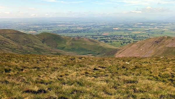
Melmerby Fell (2326ft) has a cairn but is otherwise bare. It was my last Northern Pennine Hewitt, though downhill from the fell was for me a bit special.
In my very first extended walk, back in 1971 when I had frankly no idea what I was doing, my route included a day from Alston through to Culgaith in the Vale of Eden, using the Maiden Way, a Roman Road. Now, for a precious mile, I was to repeat it. I don’t remember much from ’71. I think it was spring, but like today ideal weather for walking. I took a rest somewhere up high, thinking it was “as warm as Sussex in June”.
Having one’s 70+ self reverberate with one’s 20-something is a rare pleasure, and one I could not have begun to imagine, all those years ago.
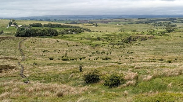
This is a great route for descent, with the Vale and the Lake District as mid- and long-distance views, and nearer to hand the strange pyramidal structures that are a feature below the Cross Fell ridge. Cuns Fell, Muska Hill and Sharp Shears are near at hand, but they grow southwards into the much larger Knock, Dufton and Murton Pikes.
We dropped down between Muska Hill and Sharp Shears and soon came to the boundary of access land. Here was a rough reminder of the world indeed. There’s a super track towards the hamlet of Ousby, which passes no habitation, which the curmudgeon landowner has marked ‘No Footpath’. But what does one do? There was now no sensible alternative. I resolved to ask very kindly for the landowner’s permission, as soon as I met them. But we didn’t.
Had there been a railway station at Ousby, it would have been a great finish. But it’s four miles away, at Langwathby. Nothing to do but get on with the road walk. We’re off road after Winskill, dodging another bull-with-cows, with a wheatfield beyond that I would have complained about, for lack of headland, if it had been in Essex.
And so end my North Pennines.
Heading towards Melmerby Fell
The Vale of Eden from the Maiden Way