
Plynlimon is the dominant hill of mid-Wales, not just for its height but also its role as source of the Severn, Wye and Rheidol; and so the most important watershed in all Wales. Three other Hewitts surround it.
South are three isolated hills of which Drygarn Fawr is the highest, in between Plynlimon and the Brecon Beacons. South-east, towards the English border, is a grouping of three hills of the Radnor Forest.
And to the north-west, with slopes leading down to Llangollen and thus not in mid-Wales but equally not in Snowdonia, is the Berwyn; its crowning height, Cadair Berwyn, overtops Plynlimon by a couple of hundred feet. I chose it to be my last Welsh Hewitt.

The view from Pen y Garn, an excellent viewpoint for Plynlimon, wind farm notwithstanding
Plynlimon and its satellites
I’d been keen to climb Plynlimon (2467ft) as part of my cross-Wales walk, and summitted on a wet day in October 2004.
However this route – a slow climb from the south-west, before descending to Afon Hyddgen and eventually Machynlleth – was designed as a long (16-mile) traverse rather than a hill day, and so I took the opportunity provided by an LDWA group in 2015 to pick up the other heights.
The Plynlimon range, Saturday 18 April 2018, 11 miles
The circuit took us from beside the Nant-y-Moch reservoir, up to Y Garn (2244ft), over Plynlimon and the non-Hewitt Pumluon Fach to Pen Pumlumon Llygad-bychan (2385ft) and finally Pen Pumlumon Arwystli (2431ft). We made our way back above Cwm Gwerin and then dropping down to the Afon Hengwm.
This was a good round and it was nice to have someone else organising and navigating. We had a cold and blowy day but it did provide us with dry weather and plenty of visibility – so, about as far removed as could be from the cross-Wales day; in cloud, this route would be tough to stay on track.

Plynlimon from Y Garn

LDWA Irregulars at the summit of Plynlimon

From Pen Pumlumon Arwysti
The in-betweeners
Dygarn Fawr, October 2008
I took my then teenage son Adrian to Llanwyrtyd Wells in October 2008, he to try out mountain bike trails, me to do a little walking. This gave me the chance to climb this interesting hill (2114ft) above Abergweysyn. We parked near Llannerch Yrfa, a little to the south of the Devil’s Staircase, a vicious little climb on a mountain road which Adrian was keen to try, before he set off on a stretch of the Lôn Las Cymru, a cross-Wales path for mountain bikers.
It was an unseasonally cold day, with some early snow and a chilly east wind. I set off on a path rising through woods until coming to open ground. Drygarn Fawr is barely a couple of miles away across the tussocky moors, its top marked by two giant cairns. From here Plynlimon to the north and the Beacons southwards were in plain sight, all outlined in white against the deep blue of the sky.
I didn’t quite repeat my route back, finding a gate (or was it stile?) that led to a forestry track for a quick descent to the car. Here Adrian was waiting, having found the MTB track all but impassable for mud.
Gorllwyn from Llanerch Cawr, Sunday 20 June 2021, five miles
I settled on the northern approach, though I regretted having thrown away an approach from the east recommended by that connoisseur of Welsh hills Jim Perrin, that had appeared in The Great Outdoors magazine a few months before.
Not far from the car park, I intersected my cross-Wales walk at the longhouse of Llanerch Cawr. I well remembered having been there in 2003, on my cross-Wales walk. An old quarry track then takes you half way, before following a thin path which rises beside the Marchnant. You could follow it as it trends eastwards and then turn right onto the summit ‘ridge’, but the ground is nowhere very difficult, nor slopes very steep.
After a while I just decided to make a beeline, near enough, for the 2011ft summit. Like Drygarn Fawr, you can’t miss the top, thanks to the great beehive cairn; there’s another, lower, away to the south-east.
The return was the reverse, more or less. I set a bearing, and found that the Caban-coch dam was pretty much in exactly the right place. That’s my helpful hint for non-misty days.
Although the ‘double’ of Drygarn Fawr and Gorllwyn looks an obvious round from the map, many sources counsel against it. The slopes to the west of the bwlch between them are notoriously boggy.

The view from Gorllwyn, with its conical cairn and then Drygarn Fawr in the distance

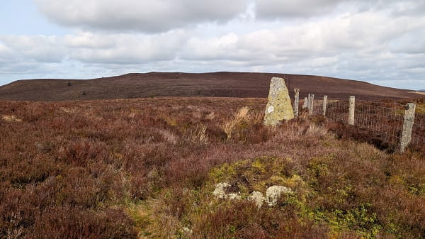
The spiral wind shelter of Pen y Garn
Pen y Garn from Gelmast corner, Wednesday 14 July 2021, four miles
A hill with a Landrover track all the way to the top! How easy could it be. And, would it be worth it?
Well yes it was; rather nice in fact. It was the first part of a double-header, as I repositioned myself from Kington, my base for the Radnor Forest hills (below), to Cwm Cwyarch, where tomorrow’s target was Glasgwm in the Arans. Indeed I was quite proud of my logistics, for in between the two hills was Machynlleth, a town I know quite well, just in time for lunch.
There was a bit of a downer in that a big SUV had plonked itself in the most obvious parking place, on a twisty road above Cwmystwyth that gets to 1200ft without every really trying.
I could just about squeeze my little Mazda onto the verge next to the gate that I actually wanted (a place that SUV could not go). From here, simply follow the track, but not without an eye on the map for there are plenty of tracks one might follow. There are a couple of big zig-zags that aren’t worth short-cutting and then a third which has does have a short-cut. It’s barely worth it, and there’s barbed wire to be ducked under half-way, so on the descent I didn’t bother.
It’s hardly the craggiest summit – the 2005ft summit is in fact a gate – but there is a rather cunning spiral wind shelter and an ace view of the Plynlimon massif. On a day with a decent breeze, it was strange that the extensive Cefn Croes wind farm was off-line.
I stayed a bit longer than I might have as I was joined by a couple (sorry, ‘elderly couple’; they would have been in their 70s too) who had followed a route up from the memorial Arch on the B4574 – mostly up through forestry, they must have been pleased to leave it. But is shows there are alternatives if you want them.
The Radnor Forest Hills
Bache Hill, Black Mixen and Great Rhos from New Radnor, Tuesday 13 July 2021, 10 miles
Plus points: three Hewitts with barely 2000ft of climbing overall. Minus points: bog, heather, things that go bang, and a hill with a big mast on top.
But there they are, tucked away in a corner of Wales where they might not be expected, and at least they have the decency to group themselves closely together. I limbered up, as I think most folks do, with an ascent of the tempting Whimble, which if it had the decency to be 35ft higher would have been much the nicest ‘bag’ of the day; an up and a down, comfy grass, almost pointy summit. Once off, there’s a farm track, and then a decision to be made. Thrutch up directly through the bracken to the top of Bache Hill (2000ft), or slant leftwards on another track? Well, bracken in July is something you don’t do.
I was quite surprised by the summit; it’s on a little mound, quite out of keeping with the summit plateau, and almost exactly the right height to afford Hewitt status to the hill, by inches.
The next day I would be climbing a hill for which the summit was a gate (Pen y Garn, above). Now, I was off for the radio mast on Black Mixen (2133ft). OK, the trig point nearby, but you get the idea. I freelanced down the sheep pasture to the col between the two hills and from there there’s an obvious track heading in the right direction; you just have to veer right from it as you close in on the summit. The broad flat top of hill 3, Great Rhos (2165ft), is blindingly obvious over to the west, but in between there is the deep depression of Harley Dingle. You wouldn’t do a beeline anyway – 500ft steeply down, then up – but it’s firmly in the grip of the munitions testers, so it’s not a matter of choice but survival.
Bache Hill had an unexpected bump for a summit; Black Mixen an unmistakable mast. At least you knew when you got there. Great Rhos … pity the poor OS team, struggling with their theodolite to get the trig point in just the right place amongst the heather. As you continue along the right-of-way on the northern edge of the plateau, somewhere you have to decide where to strike across the trackless moor. Thankfully these days Hewitt-baggers have done this for you, and continue long enough a gloopy path materialises. Take it. There is nothing better.
It would be really nice to drop into Harley Dingle for the return, but you can’t, because of all the bombs, so you have to thrutch along a fence until something like a proper path, and better ground, appears. It’s tempting to cross the fence into firing range ground – clearly some still do, assuming they can easily pick up a good path in 200 metres or so, but you really shouldn’t, and not just because the path on the map isn’t there on the ground. Just saying.
At last you’re dropping down into something that is quite pretty. Turn left onto a bridleway that crosses a stream in Davy Morgan’s Dingle, contour round a bit, and then have a grand time peering over the installations of the range. (It’s not MoD, this range, but a private facility. If you want to test out some bombs or bullets, just ring up and ask, there’s a friendly website to help.) Finally you do get into the outflow of Harley Dingle; just then remember to contour round on a path that leads directly back to New Radnor instead of dropping down to the A44 in error. (No I didn’t.)
The pictures below, clockwise from upper left: Looking back to Whimble; The summit of Bache Hill; The munitions facility; The summit of Great Rhos, looking over to Black Mixen


The Berwyn
East of Snowdonia, indeed barely ten miles from the English border, rises this range of lofty rounded hills high above the valley of the Dee.
The main ridge rises to the not-inconsiderable height of 2723ft at Cadair Berwyn, which I chose to be my last Welsh Hewitt of all, in 2022. A few years before, I’d picked up the couple of lonely hills to the north, which aren’t easy to fit into a round with the main group, but I still had to think carefully about how to structure the six hills that remained.
The two northern Berwyns, Sunday 19 April 2015, 12 miles
These two hills, Moel Fferna (2067ft) and Moel yr Henfaes (2037ft), lie a couple of miles north of the main group. There are no difficulties in the ascent, with not a crag in sight, unless you count a few bits of boggy ground – no doubt this could be much worse after prolonged rain. I climbed them with an LDWA group the day after we’d covered Plynlimon and its neighbouring heights (see above).
We started from the village of Cynwyd, rising through forestry until reaching the open hillside and following an easy track to a fence, then turning left to the summit of Moel Fferna. Later the fence was a secure guide on the lonely miles south to Moel yr Henfaes.
For a long time this hill was known by the indignity of ‘Nameless’ but it’s since acquired two, the afore-mentioned and also Pen Bwlch Llandrillo Top, this admittedly being unflattering – it just means ‘the top of the top above the top of the lane to Llandrillo’. We dropped down to it, but soon veered off for the easy descent NW back to Cynwyd.
2026 update – we were gathering Hewitts, not Simms, so we paid no attention to the little pimple on our right about half way between our two tops. This is Cefn Perfedd, a Simm, and when I started gathering those I had to revisit. There’s an account here.
Moel Fferna (2026), from the ascent track of 2015
Moel Sych and Post Gwyn from Tan-y-pistyll, Saturday 9 June 2022, nine miles
As I started to tick off the Welsh Hewitts post-lockdown, one question started to come into my mind; which hill should be last?
It soon became apparent the the final hill-group would be the Berwyn. I had six of its Hewitts left, after finishing the Hirnants the month before. Five of them fit into a very obvious round, but that ends on Moel Sych (2712ft), which not only doesn’t sound very nice, it’s not a very exciting hill. So I determined to add Post Gwyn (2182ft), something of an outlier, onto my ascent of Moel Sych.
It was actually quite a nice day out. Unusually, I hadn’t settled on my route between the two hills when I set out on the day.
The start was a much-used track that heads north up Nant y Llyn from the café at Tan-y-pistyll. There are a few bits of bogginess where the stream is crossed but the disappointment was the condition of Llyn Lluncaws, a nasty brown colour owing to something invasive spreading over its surface – what a contrast to the beautiful deep blues of the mountain lakes on Cadair Idris the month before!
But I was soon at the cairn, and it was decision time. The direct line to Post Gwyn meant getting to grips with the valley of the Afon Disgynfa. How to get there? The south ridge of Moel Sych perhaps, or down Cwm-Rhiwiau? A few sketchy paths were shown on the map, but who knows how much heather or bracken might be hidden? And of course, height lost would have to be regained later.

The path to Moel Sych above Nant y Llyn

The summit of Moel Sych
There is one other way, and that is to take the sketchy ridge heading WSW and then branching left for the last mile to the second hill. It’s boggy, allegedly, but there had been no rain for ages, so it couldn’t be that bad. Indeed it wasn’t. I started off along a path with a fence on my right but it soon became clear that a better path ran on the other side – and best of all, solid railway sleepers led me over the roughest stuff.
I knew I had to leave this path about 750 metres from a prominent cairn – in fact, something of a wind shelter – at SJ 040 309, and there find another path that led to Post Gwyn. I might have turned off a few metres too early, because I thought I could see the path heading in the right direction below a bilberry bank, but found it soon enough anyway. Conditions underfoot weren’t too bad; the path seemed to disappear nearer the summit, but there were no real difficulties.
I was a bit surprised to see anyone else on this lonely summit. They were, I found out, Rachel and Digby (“My parents had a sense of humour”). Rachel had brought Digby here because it is her ambition to climb all the Welsh Hewitts! She was just 26 hills in, but had the advantage of youth; and we had a good chat, me feeling quite the elder statesman, passing on my experience to a younger generation.

The railway-sleeper path, heading up to the wind-shelter cairn

Digby and Rachel on Post Gwyn

Pistyll Rhaeadr
There’s still a good few miles to get back to Tan-y-Pistyll, with little in the way of paths early on, apart from a stretch above a patch of forestry. Eventually, you need to head down the hill – there is a right of way shown on the map, but not the ground – down to Craig-y-Mwn. From here a steep track takes you down nearly to the valley floor, and the base of the wonderful Pistyll Rhaeadr.
It was thronged today, and why not in such beautiful weather. I reflected that I had now walked to the three highest waterfalls in the nations of Great Britain: this, High Force on the Pennine Way, and Eas a’ Chual Aluinn in Assynt. Only when doing the responsible fact-checking for this page, I found out that Cautley Spout in the Howgills is higher that High Force. But the Howgills are on my list, so that should be remedied soon.
Sunday 10 July 2022: Berwyn circuit from Tyn-y-ffridd, ten miles
Yesterday was pleasantly warm, with a bit of a breeze to cool things down; today would be hot, in the mid-20s even on the tops, with barely a hint of wind to take off the edge. Just as well I woke early, so that I could be off the hill before mid-afternoon and the worst of the temperatures.
This round is essentially a horseshoe walk around Cwm Maen Gwynedd, with Cadair Berwyn at its head.

Cwm Maen Gwynedd, with the Berwyn ridge in the distance
It’s a sharp start. The first of the day’s four Hewitts, Mynydd Tarw (2234ft), is barely a mile from the car, with over 1100ft of climbing – a relentless 1 in 5 all the way. Still, even a 71 year old with a dodgy hip and recovering from his first-ever bout of Covid can do that in 33 minutes, and by some measure it’s the steepest stuff of the day.
A mile further along comes Foel Wen (2267ft), a bit of a lump where the summit is nowhere near as clear as on the hill before. There’s a stake in the ground just the other side of a fence, which I skipped over just in case the stake was the high point. Another intervening hill, Tomle (2406ft), is higher than its predecessors, but does not have the re-ascent needed for Hewitt status. Just beyond, there are a couple of peat hags to negotiate.

Mynydd Tarw

Cadair Berwyn from just beyond Tomle
It’s easy to reach Cadair Berwyn (2723ft) from here, but I had to veer right to reach the col between it and Cadair Bronwen (2575ft). At the latter hill, I looked out over the two northern Berwyns that I had climbed in 2015 before turning back and making for my final Welsh Hewitt.
I wanted to meet someone on the summit. A reappearance from Digby and Rachel of Post Gwyn would have been very welcome, but wasn’t going to happen. I’d only seen a couple of mountain bikers, a hill runner and, far away, a couple of walkers heading down from Cadair Bronwen towards the northern hills. Surely, there must be someone up there – it’s a summer Sunday after all? Maybe the heat had put people off.
Cadair Berwyn has three bits of summit. There’s first the trig point, then a wind shelter, but the summit, the most southerly of the three, is pure rock. It was at the wind shelter that I met Gwyn – hooray! He spoke to me first – he’d wanted to eat his summit sandwich at the true summit, but the midges were a nightmare, and he was looking for somewhere lower. (I had a summit sandwich today too, a chicken and stuffing that had been steadily heating up in my pack for the last three hours and became the prime suspect in a food poisoning incident the following day.)
But we dodged the insects long enough for me to tell him of my personal milestone and appreciative he was too. That was enough. I touched the top rock of the summit, took a few selfies – not shown here, but each of them has flying beasties buzzing round my head – and dropped down far enough to have my salmonella buttie in relative peace.

Railway sleepers, like those on Moel Sych, lead to the summit of Cadair Bronwen

The trig point on Cadair Berwyn with the summit beyond
Home time now. There’s still four miles to go, the heat is building, my target is achieved, and the southern arm of the horseshoe is the least attractive part of the day. It starts well enough, a nicely graded path heading down from the col between Cadair Berwyn and Moel Sych, but there’s more fence following to come, and one section where it looks as though a fence-free path cuts a corner but the path disappears and there’s nasty heathery stuff before the fence is regained. It leads to Godor (2228ft), like Tomle not a Hewitt but a pretty good mountain name all the same.

Llyn Lluncaws from the Berwyn ridge

The path heading down from the col
It’s now relentlessly downhill from here, into calmer sheep pastures. Proper tracks start to appear, and finally a right of way turns out to be a gravelled farmers’ track. Complete with farmers, taking in the hay harvest. I have a chat with the farmer’s brother, he’s well impressed, and I get a handshake. Made my day.

The track home