
For many, the Eastern Fells mean Helvellyn and Striding and Swirral edges, and why not? Surely this is one of the classics of English hill walking.
Indeed it featured in one of my earliest hill-walks (1974). But Helvellyn is merely the centrepiece of a long north-south ridge that is well worth exploring, and by no means the only fine hill of the group.
In my August 2016 trip I chose an enterprising route up to one of Helvellyn’s main satellites, Dollywaggon Pike, and a completely contrasting line over the rounded hills to Helvellyn’s north, centred on Great Dodd. The hills in between, notably Catstycam, featured in 2024.
Catstycam and Red Tarn from Helvellyn, Ullswater beyond
North of Helvellyn
Thursday 25 August 2016. Great Dodd and its satellites, ten miles.
These rolling grassy hills to the north of Helvellyn are in many ways atypical of Lakeland, apart perhaps from the northern fells behind Blencathra, but that is all to the well and good: you have a chance of solitude.
Indeed, despite an approaching bank holiday, I saw barely a dozen people all day.
This made sense as a linear walk, starting at Dockray, which I reached by the morning bus from Glenridding. It’s a long and lonely plod from here along the old coach road.
I left the old coach road at Mosedale Beck for the straightforward, and totally untracked, climb up to the first hill of the day, Clough Head (2382ft). It’s an unremarkable summit, one of Lakeland’s loneliest outliers, but at least I had something of a view, the cloud just brushing the top.

Approaching Clough Head from the old coach road

Clough Head summit
The cloud enveloped me soon enough, on the way to the highest hill of the day, Great Dodd (2812ft), and across to Stybarrow Dodd (2766ft) as well.
Things started to improve over Green Side (2608ft), one of the few Hewitts that is not also a Wainwright, and were markedly better at the day’s last hill, Sheffield Pike (2215ft). Though the lowest hill of the day, Sheffield Pike was in many ways the most interesting, jutting out craggily above Ullswater.
The safe way off is to backtrack to the hause to the west and drop down the zig-zags to Glenridding Beck, but a path headed off encouragingly to the SSE, so I thought I would try that. A couple on the top with me were debating whether to go that way, but as I managed to stumble awkwardly at the cairn, I don’t think they wanted to follow! Yet the path works, following down the ridge of Heron Pike to a bracken-fringed path circling Glenridding Dodd.

Bemused sheep on Stybarrow Dodd

The interesting way off Sheffield Pike
All that remained now was to decide which pub to eat at, and as the Traveller’s Rest at the top of Glenridding village soon appeared, this was not a difficult choice. And later, the zig-zag couple stopped too.
Helvellyn
Wednesday 12? June 1974. Helvellyn by Striding Edge and Swirral Edge.
Part of my Part 1 Mountain Leadership Course. (Never bothered with Part 2 as I reckoned I’d never cope with the rope work, nor ever use it either.)
The classic way up and down, from Glenridding. We were staying on the other side of the lake so had to row over to start with, not a problem in your early 20s.
Tuesday 23 July 2024. Helvellyn by Catstycam and Sticks Pass, ten miles.
With two LDWA colleagues, Carrie and Isabel. A useful variation on the classic round, with the bonus of ascending a scramble (Swirral Edge) that most people descend.
From Glenridding it’s a simple enough path up to Red Tarn, before cutting off left on the SW ridge of Catstycam (2920ft). The trouble is, super-fit Carrie (planned entrant, Ultra Trail du Mont Blanc race 2025), was way ahead when we got there so we missed the turn and had to freelance for a bit to reach it. Catstycam is a shapely hill with a pointy little summit to match, so it’s certainly worth the climb.

On the way to Catstycam

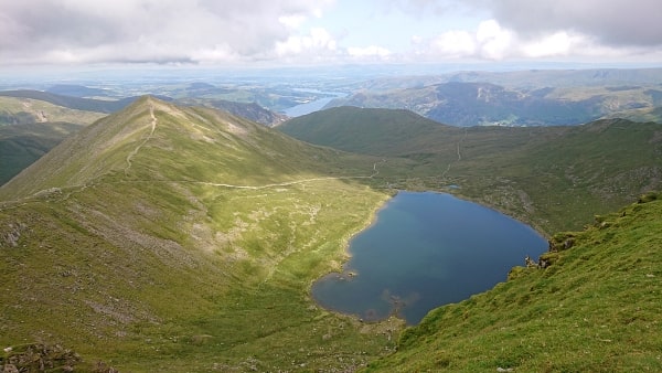
Helvellyn from Catstycam
The fun of the walk is the scramble up Swirral Edge. Route finding is not always obvious, though there are no real technical difficulties. All I know is that I had a broad smile on my face when the climb was finished. It’s then a simple matter to veer round to the summit of Helvellyn (3117ft), a busy place on most days and certainly today.
Helvellyn’s Lower Man doesn’t have the re-ascent needed for its own Hewitt status but the rather bland Whiteside (2831ft) does. Far more interesting is the next hill along, Raise (2897ft), with its rocky summit.

Swirral Edge

Carrie and Isabel on Raise
There’s a descent col between Whiteside and Raise but we continued north to Sticks Pass, at 2421ft one of the highest Lakeland passes. It’s an easy descent from here, albeit with steep zig-zags to the valley floor, through mining relics, to Helvellyn hostel and the lane back to Helvellyn. Just like with the Sheffield Pike route above, the Traveller’s Rest proved too great a temptation to pass.
South of Helvellyn
Friday 26 August 2016. Dollywaggon Pike via The Tongue, ten miles.
This was a much brighter day than ‘north of Helvellyn’ above, with cloud well above the tops. There’s a cluster of hills between Helvellyn and Fairfield which don’t always get their due, Dollywaggon Pike and St Sunday Crag amongst them, and it was a good day to explore them.
This route set itself nicely for a circular walk from Patterdale village, though to get there I had first to take the bridge over Goldrill Beck, the day’s main objective in sun-dappled view.
After munching on a breakfast sarnie at the post office, there was a long walk in down Grisedale, a typical Lakeland dale and so a joy to be following.

Dollywaggon Pike from Goldrill Beck

In Grisedale
At the climber’s hut of Ruthwaite Lodge, where the Coast-to-Coast path heads down from Grisedale Tarn, there’s an interesting route that heads up to Dollywaggon Pike (2810ft) via The Tongue. It’s not quite a scramble, but it is steep, and there’s the chance to get up close and personal with a bit of rock.
I was never quite in doubt of my route finding, but there was one little gully which seemed a little more committed than most of the route: just when I was beginning to be a tad uncertain, there was a little cairn right in the middle!

The route to the Tongue above Ruthwaite Lodge goes to the left of the becks
The route soon crosses to the NE prow of the Pike, a grand way to reach the summit.

Approaching Dollywaggon Pike summit
Looking westish to Scafell Pike and its companions, the weather seemed to be closing in – indeed walkers over there were probably having some unscheduled rain.

Looking west from Dollywaggon Pike
Before St Sunday Crag I had one other hill planned, Seat Sandal (2415ft). Unfortunately it’s not remotely as good as the other two, but it’s in the area so might as well be taken. I dropped steeply and directly off Dollywaggon to a saddle just above Grisedale Tarn, and then went straight up the other side, which might have been called Seat Sandal’s north ridge if it did proper ridges.
The box duly ticked, I headed down to Grisedale Hause, then contoured above the tarn for a while before heading up to Deepdale Hause – it was relief to be on good tracks again. The ground then rises inexorably up what is undoubtedly a ridge, the SW ridge of St Sunday Crag (2756ft).

Near the top of St Sunday Crag
From here the path heads relentlessly down the hill’s NE flank back towards Grisedale bridge, but rather than drop directly to the beck, I took a little path which twisted through Glenamara Park before arriving at the back door of the Patterdale Hotel.
Fairfield and its neighbours
Saturday 31 March 2007. The Fairfield horseshoe, 9½ miles.
My wife Barbara joined me for this. She coped fine, indeed her diary noted ‘done with relative ease’, but she hasn’t undertaken a mountain walk since. Shame.
It’s one of the classic Lake District walks, around the valley of Rydal Beck. We started from Rydal village and walked back to Ambleside, where we were staying for a few days. Dry and cloud off the tops with little wind, a result for early spring.
Four Hewitts are climbed: Great Rigg (2514ft), Fairfield (2865ft), Hart Crag (2700ft) and Dove Crag (2598ft). There are several more passed on the way with other designations, which I might get round to noting if I ever attempt those lists.

On the way to Fairfield

On Fairfield summit
Saturday 4 August 2018. Little Hart Crag and Red Screes, 9 miles.
A fairly miserable, if not typical, Lakeland summer day, with a scudding wind, rain and low cloud. I don’t get too many of these, in all honesty.
The key to these is Scandale Pass, which like the motor road across Dunmail Raise leads from Ambleside to Patterdale. Little Hart Crag (2090ft) rises to the north of here, on a simple out-and-back. Red Screes (2555ft) lies to the south, and is the high point above the eponymous scree which rises from the Kirkstone Pass.
My main memory is a tent on the top of Little Hart Crag, into which I was beckoned inside. Its resident geezer seemed very pleased to have surplus chocolate donated to him.
No pictures alas