
Visitors to Snowdonia, almost without exception – myself included – head first to Snowdon itself and then branch out to the other ‘glamour heights’ of the Glyders and the Carneddau.
However they are surrounded by a varied group of smaller hills that are well worth discovering in their own right, and not simply on the way to something bigger.
This certainly was my own approach, with a prelude of the two classics, the Snowdon Horseshoe and Tryfan and the Glyders right at the start of my serious hillwalking. I took on the Carneddau traverse as part of my cross-Wales walk in 2006, which the year before had also featured the excellent 2861ft Moel Siabod.
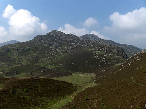
Alas, no photographs owing to a PC theft and lack of backup. The very nice pic opposite is the Wikipedia image of Creigiaiu Gleision with Creative Commons attributions here.
Carneddau outliers
Of the sub-3000 footers, Drum and Pen yr Helgi Du featured on ascents of the Carneddau 3000-footers in 2006.
I came back five years later specifically to pick them up alongside the remaining hills of this group, and some very fine ones are included too.
Thursday 14 April 2011: Rowen to Rhiwiau Isaf via Tal y Fan, six miles
Tal y Fan is the most northerly Hewitt in Wales, and at 2001ft it qualifies by the skin of its teeth. It would be a shame if it were ever downgraded, for it punches well above its weight: its isolated position gives it great seaward views, including Anglesey, the high moorland of the Clwydians eastwards, and mountain views south to the main Carneddau massif.
I travelled up from London on a morning train and early afternoon bus to the village of Rowen, a couple of miles from the top. I’d planned to take the northwards path from near Rhiw hostel before gaining the ridge, but forgot to turn off so ended up off-track but through an interesting area of old settlements. Once back on the ridge, I continued over the summit and the accompanying, slightly lower, Foel Lwyd (1969ft, and hence a Simm) before dropping down to an old Roman track which took me easily towards my destination, the B&B of Rhwiau Isaf.
Friday 15 April 2011: Rhiwiau Isaf to Bethesda via Llwytmor, Foel-fras, Bera Mawr and Drosgl, 11 miles
It wasn’t too difficult to reach the North Wales Path a mile or so from the B&B, although not quite by the sometimes indistinct right-of-way, and then branch out on the water company track to Llyn Anafon.
Llwytmor (2785ft) rises directly above; I just made my way round the N end of the llyn and than made my own way up the steep ground beyond, eventually lessening to the summit itself.
From here you get a sense of the Carneddau plateau.
Gradients are easy all the way to my last hill, and it’s easy to pick your own line for those bits where there might not be a path heading your way.
I didn’t need to pick up Foel-fras (3097ft), a 3000-footer that I’d taken on my Cross-Wales walk in 2006, but having got this close it would have been perverse to have missed it out.
(It has to be said that in bad mist or cloud navigation would have been far more complex – no helpful walls to guide you, as on my 2006 Carneddau traverse.)
Next was Bera Bach (2648ft). Now, ‘bach’ means little in Welsh, but it’s higher than its twin Bera Mawr (‘big’; 2605ft), so I’d assumed it was the Hewitt and didn’t plan to cross over Mawr. Until I looked across to it; an even more inviting, tor-style summit than the one I was actually on. A good thing I did too; it turns out that Bach is the Hewitt, for Mawr is considered to be merely a top of another nearby 3000-footer, Carnedd Gwenllian. My last Hewitt of the day was Drosgl (2484ft), a simple stroll contouring back round Bera Bach’s lower slopes.
The former mining town of Bethesda is three miles downhill from Drosgl, an easy WSW beeline to the intake wall, then rights of way and lanes into the town. I had made such good time that I had two hours to kill before my bus to the bunkhouse. Writing these notes up ten years almost to the day since the walk, although I can remember many details of my time on the plateau, I have no idea at all how I spent my time in Bethesda.
Saturday 16 April 2011: Gwern Gof Isaf to Capel Curig via Pen Llithrig y Wrach and Creigiau Gleision
These two hills rise either side of the deepest lake in Snowdonia, Llyn Cowlyd. That means an unavoidable drop down to the head of the lake, but there are no great difficulties, at least with the first hill.
I reached Pen Llithwrig y Wrach (2621ft) by a path to Tal-y-braich and then farm track to a leat contouring around 1400ft that drains the deepest lake in Snowdonia, Llyn Cowlyd. From the leat, it’s just a case of taking an ENEish line towards the summit ridge.
From the top, Creigiau Gleision (2224ft) is only a mile away, but with the llyn and the two steepest slopes of the two hills in the way, a direct line is not going to work!
So it was a case of retrace steps down the ridge and keep going to a path junction just below the llyn inflow. From here there’s a lot of heather, ENEish again, though I found a way without too much bashing.
When you get to it, the ridge is a delight, sporting two tops – the further is the lower, and while it’s not strictly necessary to climb it, the there-and-back is not much more than a mile and much too good to miss. In good weather anyway – mine was passable, cloud well over the tops if a bit overcast.
The descent route was fun too, over a knobbly little ridge of sorts which included the subsidiary hill of Crimpiau. The Nant y Geuallt then leads down to Capel Curig, and for me the Sherpa bus back to the bunkhouse.
Snowdon’s western satellites
Three of Snowdon’s neighbouring sub-3000ft Hewitts – Y Lliwedd (2947ft), Yr Aran (2451ft) and Moel Cynghorion (2211ft) – all feature on my Snowdon page because I’ve linked them to that grand summit.
Two other Hewitts are more distant from Snowdon itself, but I fitted them into a walk-in to Rhydd-ddu that follows.
Friday 30 March 2012: Llanberis to Rhydd-Ddu via Moel Eilio and Foel Gron
Travelling up in the morning from London to Llanberis, I had a mug of tea in the town’s legendary walkers’ cafe Pete’s Eats before heading up the lane to the youth hostel. Beyond, you’re soon in open country, and the Braich y Foel ridge of Moel Eilio (2382ft) presents itself.
It’s straightforward, with easy gradient, and wall then fence to follow to the summit. It’s a great viewpoint for the Nantlle ridge, the next day’s objective, as well as Snowdon itself.
The continuation to the next two hills is scarcely more demanding, being mostly downhill and with a steep scarp slope on the left to handrail you forward. The biggest difficulty was surmounting the barbed wire fence which inconveniently stuck itself between the path and the actual summit of Foel Gron (2064ft), just a few yards the wrong side. After the subsidiary top of Foel Goch (1983ft, a Simm), Bwlch Maesgwm is an easy stroll, and from there a track runs down towards the enclosed lands, field paths then taking me to the road just 1km from Rhydd-Ddu itself.
East of Tryfan
The Glyders have more 3,000-footers (five) than lower Hewitts (four). I had picked up the two northernmost of the latter (Carnedd y Filiast 2695ft and Mynydd Perfedd 2665ft) alongside Y Garn and Elidir Fawr in 2006, but had to wait five years to climb Y Foel Goch (2636ft) and Gallt yr Ogof (2499ft), the easternmost of the range.
Sunday 17 April 2011: Gwern Gof Isaf to Capel Curig via Y Foel Goch and Gallt yr Ogof
This was the last half-day of the same trip that features in the Carneddau section above. From my base at Gwern Gof Isaf, the first of the two hills is reached by slowly ascending the ridge to the west of Nant yr Ogof, keeping just below its crest, as far as Llyn Caseg Fraith, at 2430ft one of the highest bodies of water in Snowdonia, nestled in a saddle below Glyder Fach.
I had started early – I had a timed ticket on a train at a station that was still many miles away – but had a peach of a day, early mist and dew soon going. And of course Tryfan is rising in its grandeur, lit by the morning sun. A wild camper was just preparing to strike base at the llyn, and we both had broad smiles on our faces. (This may have been a key moment in me deciding that wild camping was maybe worth a try.)
Y Foel Goch is hardly any height above the llyn and easily gained. Gallt yr Ogof, barely half a mile away, follows without difficulty. Then it’s just a case of descending by a broad ridge, one slight rise of substance to Cefn y Capel, and dodging any boggy bits that may be around until the village of Capel Curig is attained. All one has to do then is kill some time (which may have involved breakfast) before the Sherpa bus to Betws y Coed hoves in to view. What a nice way to spend a morning.